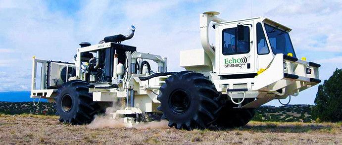
Echo Geotech’s non-intrusive Land-streamer is ideally suited to urban environments
Echo Geotechnical delivers continuous, high resolution, subsurface profiles, reducing risk and optimizing opportunities for our clients. Our multi-component land streamer system design allows us to simultaneously employ multiple techniques to extract subsurface physical properties for geotechnical, mining and hydrogeological problems.
ACQUISITION
- Cost efficient Vibroseis energy source and streamer with 72 3C receivers using minimal crew
- Includes MASW acquisition, SH and P-wave in single pass
- Non-intrusive – ideal for urban settings or dams and levees
- Large number of channels recorded for full section – shallow to deep
PROCESSING
- Full wave processing – SH and P-wave from same data
- High resolution imaging in low velocity soils up to 200 meters
- Shear modulus estimates along continuous profiles delivered for engineering analysis
INTERPRETATION
- Quickly identify subsurface features such as tunnels, fluids, low shear strength materials and buried channels
- Stratigraphic and structural profiles validated with available well and CPT data
- Integrate well data with profiles to create 3D visualization
Design Parameters
Geotechnical engineering relies on a thorough understanding of the subsurface to ensure safe and stable structures. Design Parameters are the critical factors we evaluate to inform your project’s foundation design. These parameters include:
Shear moduli: This measures the soil’s stiffness, a crucial factor in determining its ability to resist loads and deformations.
Bedrock profiling: Knowing the depth, type, and characteristics of the underlying bedrock is essential for foundation design and excavation planning.
Soils lithology/continuity: Understanding the soil types (lithology) and their continuity (distribution and layering) allows us to assess the soil’s strength, bearing capacity, and potential for settlement.
By evaluating these design parameters, we can provide a comprehensive picture of the subsurface conditions and ensure your project is built on a solid foundation.
Geohazard Identification
Before construction begins, it’s crucial to identify any potential geohazards that could threaten your project’s safety and success. Geohazard Identification is a vital step in the geotechnical engineering process. Through advanced techniques, we can detect hidden hazards such as undetected voids or cavities underground that can pose significant risks of settlement or structural collapse. Our investigation methods can identify these hidden threats and allow for proper mitigation strategies.
By proactively identifying these hazards, we can significantly reduce project risk. This allows for informed decision-making, potentially saving time and money in the long run. Our goal is to ensure your project is built on a safe and stable foundation, free from unforeseen geohazards.
Applications
Geotechnical engineering plays a critical role in ensuring the stability and safety of a wide range of infrastructure projects. Here are some key applications of our expertise:
Earth dams and levees: We provide the geotechnical analysis and design parameters necessary for constructing safe and reliable earth dams and levees, ensuring they can withstand water pressure and protect against flooding.
Transport corridors: From roads and bridges to railways and airports, geotechnical engineering is essential for designing and constructing stable transportation corridors. Our services ensure these vital links can handle heavy traffic loads and various environmental conditions.
Geotechnical Engineering Design: Our core expertise lies in geotechnical engineering design. We analyze subsurface conditions, assess potential hazards, and recommend foundation solutions that optimize project safety and performance.
Earth Dams & Levees
THE PROBLEM
Tens of thousands of earth dams and levees around the world are aging increasing risk of seepage and failure. Current methods of investigation include (Cone Penetration Test (CPT), Becker Penetration Test (BPT), standard Penetration Test (SPT) or Shear Wave Velocity test (SWVT or MASW)). Interpolation between the discrete sample points obtained from these methods can miss critical areas of concern.
ECHO GEOTECH’S SOLUTION
Echo Geotechnical’s Landstreamer technology provides continuous shear moduli and sub-dam seismic profiling to image information between discrete point tests with a non-destructive profile along the top, toe or sublevels of these dams.
OUR ADVANTAGE
Our approach offers a comprehensive understanding of your earth dam’s health. We can identify weak areas requiring reinforcement, investigate the underlying soil structure for potential erosion or low shear strength, and perform SWVT testing alongside subsurface investigations down to 50 meters – all in a single, non-intrusive pass. This delivers high-resolution, continuous geologic data without disturbing the surface or requiring drilling along the dam. This translates to cost savings for you, while also allowing for optimal placement of more expensive CPT and drilling tests if necessary. In short, Echo Geotech provides the information you need to make informed decisions and optimize solutions for your earth dam project.
Geotechnical Engineering
THE PROBLEM
A key characteristic of soils required by geotechnical engineering investigations is the shear moduli or strength of the top 30 meters of soil to ensure overlying buildings/structures are not at risk of collapse due to soil structure.
Currently drilling and/or CPT’s are conducted at discrete points within a construction site. Low shear strength areas between or below these discrete points are often missed increasing the risk of catastrophic hazards in the future or additional unplanned construction costs.
ECHO GEOTECH’S SOLUTION
Echo Geotechnical’s non-intrusive Land-Streamer is ideally suited to urban environments and provides continuous profiles of the subsurface up to 200 metres in depth reducing the risk of undetected potential hazards.
OUR ADVANTAGE
High resolution Land-Streamer profiles cost less than penetration tests and may reduce the number of penetration tests required and optimize their placement.
Identifying areas of weak soil strength along continuous profiles prior to construction should mitigate the risk of significant disastrous consequences during and after construction.
Transportation Infrastructure
THE PROBLEM
Subsurface characterization in transportation corridors is key to initial construction design and long term maintenance including investigations of roadway subsidence and sinkholes for example.
Key geotechnical parameters may include bedrock depth, rock type, layer boundaries, water table, weak zones, expansive clays, natural cavities and/or abandoned mines etc..
“Geophysical” techniques routinely used for geotechnical highway and railway engineering investigations are often limited either in depth of penetration and/or to simple stratigraphy:
- GPR methods for example are limited to a few meters in clays and tills
- Refractions methods are limited to 2 or 3 layers with increasing velocity
- MASW techniques can provide shear velocity but only to limited depths and only in simple stratigraphy
ECHO GEOTECH’S SOLUTION
- Continuous profiles of the subsurface using Echo Geotechnical’s non-intrusive Land-streamer ideally suited to data collection in transportation corridors.
- MASW, SH AND P-wave data collection in a single pass
- The vertical resolution of shear waves acquired using the Landstreamer is 5 times that of conventional p-wave seismic and can provide usable information as shallow as 6-8 meters depth and as deep as 200+ meters.
- The design and data analysis of our system can efficiently cover 3-4 km/day with interpreted results provided in most case within 24-48 hrs
OUR ADVANTAGE
- Continuous seismic profiles support deeper investigations for hazards such as abandoned mine workings, low shear strength alluvial clays, voids and complex lithologies such as buried channels.
- Continuously samples the subsurface between known drill holes or other data points.
- Ideally suited to work on paved or gravel roads as the 3 component geophones travel on 10″ long sleds that drag behind the vibrator – no “planting” of geophones typical of most seismic surveys required.
- Shear wave reflection technology is a “new” offering that characterizes the shear velocities of the underlying material, identifies voids and mine workings accurately to depths of 100+meters.