
Geophysical Exploration
At Echo Geotechnical, we understand the critical role subsurface data plays in your project’s success. Our state-of-the-art equipment provides quick, accurate, and non-intrusive assessments of your site. We combine advanced subsurface profiling with targeted drill holes and cone penetration tests (CPT) to create a comprehensive picture of the ground beneath your feet. This powerful combination fills the gaps between traditional test holes, revealing the hidden complexities that could impact your project. By providing a deeper understanding of your subsurface environment, we help you make informed decisions that minimize risk and reduce overall project costs.
- Cost efficient Vibroseis energy source and streamer with 72 3C receivers using minimal crew
- Includes MASW acquisition, SH and P-wave in single pass
- Non-intrusive – ideal for urban settings or dams and levees
- Large number of channels recorded for full section – shallow to deep
- Full wave processing – SH and P-wave from same data
- High resolution imaging in low velocity soils up to 200 meters
- Shear modulus estimates along continuous profiles delivered for engineering analysis
- Quickly identify subsurface features such as tunnels, fluids, low shear strength materials and buried channels
- Stratigraphic and structural profiles validated with available well and CPT data
- Integrate well data with profiles to create 3D visualization
Uncover the unseen before you dig. Know your subsurface, and minimize risks.
Advanced Subsurface Imaging
We go beyond basic profiles with our cutting-edge technology. Our multi-attribute subsurface profiling delivers a wealth of high-resolution data in a single pass. This efficient approach captures critical details like shear moduli from SH reflection, MASW, and compressional (P-wave) data. This combined approach translates to clearer, more actionable insights for your project, empowering you to make confident decisions in geotechnical, mining, and water resource applications.
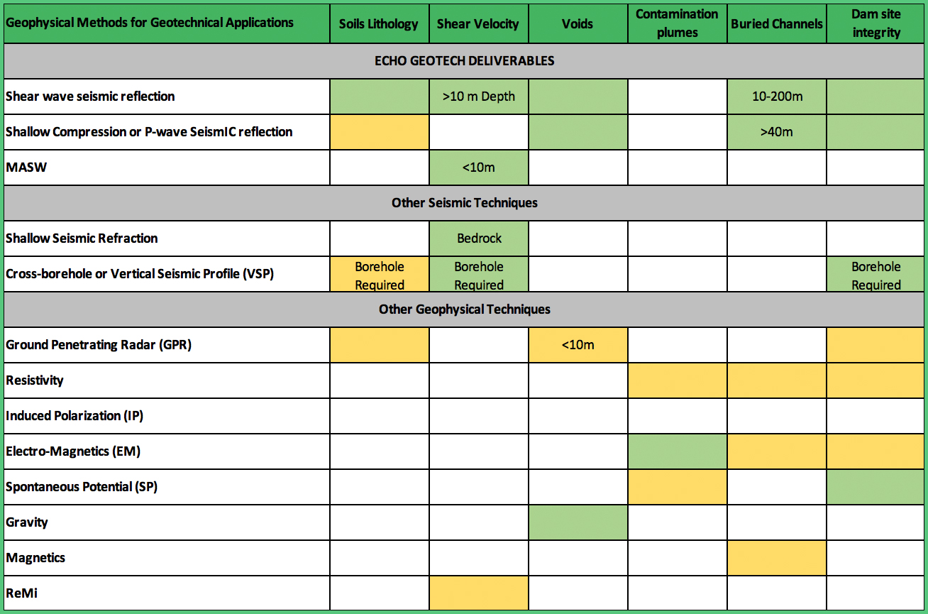
Click the chart below to see applications of our services.
David Schieck:
A Seismic Visionary Leading the Way
David Schieck, founder, brings over 30 years of experience in seismic acquisition, processing, and interpretation to the table. This expertise spans both shallow seismic applications in geotechnics and deep seismic exploration in the oil and gas industry.
A Pioneering Journey:
David’s journey began in the 1980s, where he honed his technical skills by writing code and leading a team developing groundbreaking 3D seismic processing techniques. With a Master’s of Science specializing in ground roll dispersion, he furthered his knowledge by applying it to real-world challenges, mapping low-velocity, high-liquefaction clays in South America.
Building Expertise & Innovation:
Throughout the 1990s and early 2000s, David’s entrepreneurial spirit led him to start, grow, and ultimately sell a successful engineering and environmental seismic company in Southwestern Ontario. This venture focused on water resource exploration, mining exploration, and geotechnical site characterization, laying the groundwork for his future endeavors.
David Schieck
Echoing Innovation
After a decade as a consulting geophysicist in the North American oil patch, David spearheaded the creation of Echo Environmental and Geotechnical Services Ltd. This subsidiary of Echo Seismic specifically targets engineering, mining, and water resource applications of seismic technology, capitalizing on his expertise in shear wave soil investigations.
Leading with Unparalleled Results:
David’s combined experience in design, processing, and interpretation across both shallow and deep seismic applications positions him to deliver unmatched project outcomes in terms of data quality and effectiveness. Under his leadership, Echo Geotech has established a strong track record of success, completing projects across the mining and water resource sectors in Western Canada.
The “Shear Wave Land Streamer”: A Revolutionary Approach
David’s expertise has been instrumental in the development of innovative technology like the “Shear wave land streamer.” This revolutionary tool repurposes large-capacity exploration seismic equipment and combines it with cutting-edge Vibroseis control electronics and top-of-the-line GPS technology. The result? A non-intrusive method for subsurface profiling, transforming how near-surface soil investigations are conducted.